Thailand Dive Site GPS Co-ordinates
Written by Stephen Burton
United Kingdom Wreck Listings courtesy of www.thewreckssite.com
All the WGS-84 GPS co-ordinates you’ll ever need
![]() Simply cut and paste the co-ordinates into Google Earth to view the location.
Simply cut and paste the co-ordinates into Google Earth to view the location.
Co-ordinate format kindly updated by Tim Bass, Thailand
Of course…don’t forget to rent a good boat equipped with side-scan sonar, radar, good communication systems, a little purple book of ‘fisherman’s net snag marks ‘and a top class sea-worthy crew for the more distant dive sites…If you want to stand a ‘chance in hell’ of really finding it… and getting back home!
Samui / Koh Tao GPS Fixes
click here to send more co-ordinates to ThaiWreckDiver.com
-
Big Buddha Dive Boat Pier, Samui N09° 33.624′ E100° 03.468′
-
Big Buddha Speed Boat Pier, Samui N09° 33.540″, E100’03.397′
-
Bandon Ferry Pier, Samui N09° 10.913′ E99° 21.963′
-
Bophut Pier, Samui N09° 33.635′ E100° 01.885′
-
Car Ferry Reef, Samui N09° 29.229′ E99° 55.202′
-
Car Ferry Pier, Samui N09° 28.898′ E99° 55.474′
-
Donsak Ferry Pier, mainland N09° 19.765′ E99° 44.612′
-
Chumphon Pinnacles #1, Koh Tao N10° 10.349′ E99° 46.721′
-
Chumphon Pinnacles #2, Koh Tao N10° 10.332′ E99° 46.763′
-
Green Rock, Koh Tao N10° 07.541′ E99° 48.618′
-
Haadrin Pier, Koh Pangnan N09° 40.463′ E100° 04.631′
-
Hin Yippon Lek, Nangyuan N09° 48′ E99° 43′
-
Japanese Gardens, Nangyuan N10° 07.121′ E99° 48.910′
-
Lighthouse Dive site, Koh Tao N10° 07.267′ E99° 50.695′
-
Malibu, Chaweng, Samui N09° 31.715′ E100° 03.747′
-
Mango Bay, Koh Tao N10° 07.261′ E99° 50.091′
-
Koh Matsum, Samui N09° 22.641′ E99° 58.707′
-
Nathon Pier, Samui N09° 32.155′ E99° 55.837′
-
Au-Luuk Bay, Koh Tao N10° 03.985′ E99° 50.488′
-
Red Rock, Koh Tao N10° 03.742′ E99° 50.708′
-
Sail Rock, Samui/KPN N09° 56.738′ E99° 59.398′
-
Samran Pinnacles#1 , Samui N09° 57.875′ E99° 54.941′
-
South West Pinnacles, Samui N09° 59.947′ E99° 46.750′
-
White Rock, Koh Tao N10° 06.484′ E99° 48.826′
-
4-5 Islands, Samui N09° 26′ E99° 54′
Pattaya region GPS Fixes
click here to send more co-ordinates to ThaiWreckDiver.com
-
H.T.M.S Khram Wreck N12° 55.955′ E100° 41.591′
-
Koh Laan, Pattaya N12° 53.957′ E100° 46.612′
-
The Bremen Shipwreck N12° 40.092′ E100° 48.852′
-
The Hardeep Wreck,28m N12° 31.965′ E100° 57.355′
-
Hardeep Wreck N12° 31.979′ E100° 57.374′
Pattaya underwater pinnacles
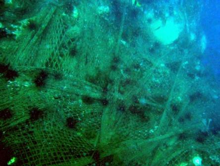
Photo of nets on Hin Yai, Pattaya by Charlie Frost diving from ‘The Sirens of the deep’ at Pattaya Dive Centre
-
Hin Yai N12° 26.099′ E100° 57.400′ (Behind Hin Chalaam)
-
Hin Pra N11° 51.060′ E102° 24.779′
-
Hin Rap N11° 54.239′ E102° 19.040′
-
JL Pier N12° 32.152′ E1015° 5.556′
-
Leam Ngop N12° 10.080′ E102° 23.430′
-
Asia Pottery Wreck N12° 54.943′ E100° 50.166′
-
Shark Pinnacle N12° 49.417′ E100° 42.689′
-
Pattaya Wreck#1 N12° 18.217′ E100° 27.929′
-
Pattaya Wreck#2 N12° 18.173′ E100° 24.988′
-
Pattaya Wreck #3 N12° 18.573′ E100° 25.179′
-
Pottery Wreck, Pattaya N12° 54.943′ E100° 50.166′
Other unconfirmed Pattaya region Wreck sites(from an old Naval Chart of Pattaya region)
-
N12° 54.0′ E100° 44′ 30.5” depth 12m, wreck PA
-
N12° 50.0′ E100° 44′ 26.5” depth 12m, wreck PA
-
N12° 35.0′ E100° 44′ 32.5” depth 13m, wreck
Samaesan “Deep Tech Diving Sites”
click here to send more co-ordinates to ThaiWreckDiver.com
-
Samaesan N12° 35.744′ E100° 57.454′
-
Shark Fin rock, N12° 49.417′ E100° 42.689′
-
Wreck ‘C’ N11° 57.042′ E102° 25.907′
-
Wreck Rin N12° 47.309′ E100° 42.123′
-
Top of Cliff 50-65m N12° 31.842′ E100° 56.137′
-
Deepest Point, 85m N12° 32.322′ E100° 57.60′
-
Deepest Point, 85m N12° 32.282′ E100° 57.579′
-
Slope 74m N12° 31.719′ E100° 56.165′
-
Slope 72m N12° 32.329′ E100° 57.584′
-
Slope 62m N12° 32.316′ E100° 57.731′
-
Slope 61m N12° 31.844′ E100° 56.135′
-
Slope 62m N12° 32.287′ E100° 57.711′
-
Wall, top at 40m N12° 32.173′ E100° 57.322′
-
Shark fin 82m N12°31.616’ E100°55.928’
-
Shark Fin 50m N12°31.840’ E100°56.156’
-
Shark Fin 60m N12°31.793’ E100°55.674’
-
Shark Fin 75m N12°31.587’ E100°55.769’
-
Shark fin 80m N12°31.579’ E100°55.859’
- Shark fin 82m N12°31.616’ E100°55.928’
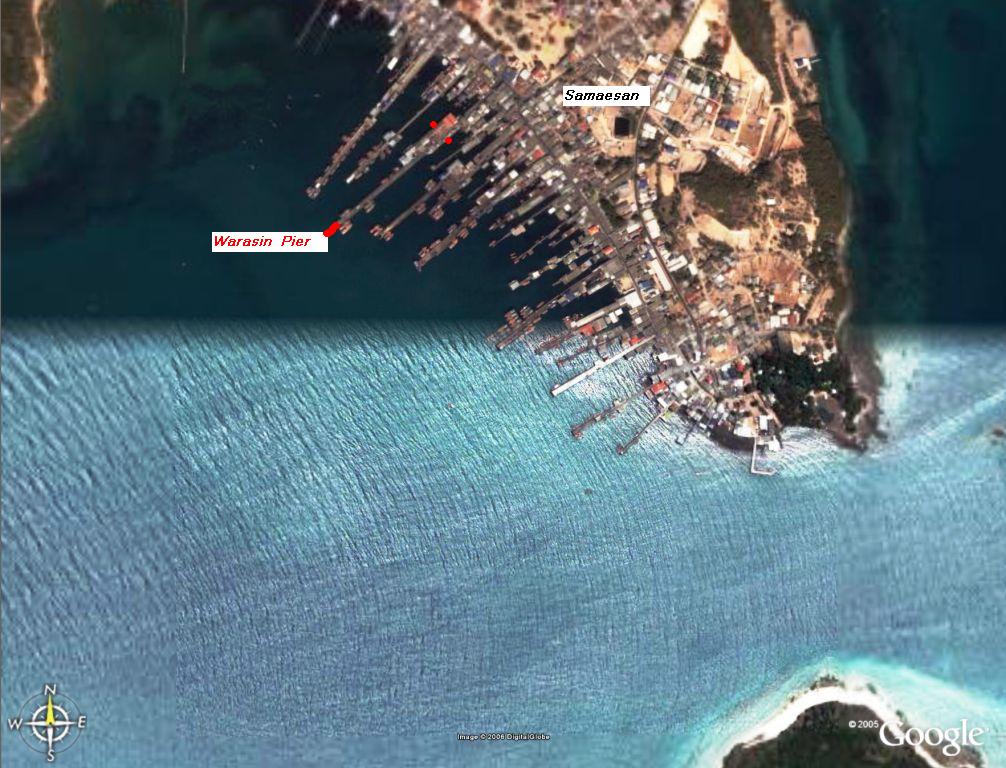
Samaesan Fishing Port – Dive Boat Moorings
-
The Warrasin Pier (tip) N12° 35.876′ E100° 57.372′
-
The Warrasin Pier (birth) N12° 35.905′ E100° 57.436′
แหล่งดำน้ำในเขตสัตหีบ เกาะคราม – Sattahip and Ko Kram dive sites
Courtesy of Khun Berm of Marlindivers [email protected]
- เกาะเตาหม้อ Ko Tao Mo N12° 37.785′ E100° 52.175′
- เกาะยอ Ko Yor N12° 39.584′ E100° 53.896′
- เกาะอีเลา Ko I Lao N12° 39.584′ E100° 53.895′
- เรือจมเพชรบุรีเบรเมน Petchaburi Bremen N12° 40.089′ E100° 48.821′
- เกาะอีร้า Ko Ira N12° 40.329′ E100° 49.432′
- หินขี้เสือ Hin Ki Sua N12° 40.96′ E100° 49.45
- หินแก้วสมุทร Hin Kaew Samoot N12° 41.143′ E100° 49.159′
- หินขี้ปลา Hin Ki Pla N12 41.332 E100° 48.685′
- หินโบราณ Hin Boran N12° 39.958′ E100° 47.40′
- หินตา Hin Ta N12 40.262 E100° 47.160′
- หินยาย Hin Yaai N12° 40.10′ E100° 47.08′
Rayong Dive Sites
click here to send more co-ordinates to ThaiWreckDiver.com
-
HIN ALHAMBRA N12° 25.702′ E101° 39.981′
-
Hin Alhambra#2, N12° 25.815′ E101° 40.041′
-
Baan Pae Pier N12° 37.547′ E101° 26.512′
-
Hin Alhambra N12° 25.700′ E101° 40.000′
-
Hin AI-Lop1 N12° 33.553′ E101° 47.805′
-
Hin Ai Lop2 N12° 32.803′ E101° 47.423′
Koh Chang (South of Rayong Dive Sites
click here to send more co-ordinates to ThaiWreckDiver.com
-
Koh Rang Pinnacle N11° 48.630′ E102° 22.300′
-
Koh Chang Wreck N11° 57.642′ E102° 25.907′
Koh Sri-Chang (North of Pattaya) ‘Mud Diving’ Sites…get to feel the wrecks’
click here to send more co-ordinates to ThaiWreckDiver.com
-
KSC Wreck1a N13° 14.886′ E100° 40.962′
-
KSC Wreck1b N13° 14.886′ E100° 40.950′
-
KSC Wreck2 N13° 15.075′ E100° 41.150′
-
KSC Wreck3 N13° 18.680′ E100° 41.100′
-
SunFlower Wreck N13° 09.480′ E100° 50.790′
Prachuap Siri-Khan dive Sites- “The Liberty Wrecks”
click here to send more co-ordinates to ThaiWreckDiver.com
-
Prachuap Wreck1 Prachuap SiriKhan N12° 18.217′ E100° 27.929′
-
Prachuap Wreck2 Prachuap SiriKhan N12° 18.173′ E100° 24.998′
-
Prachuap Wreck3 Prachuap SiriKhan N12° 18.573′ E100° 25.179′
Phuket GPS Fixes
click here to send more co-ordinates to ThaiWreckDiver.com
![]() This section being worked on. Please bare with me with this mammoth task. All assistance with provision of Phuket GPS fixes will be greatly appreciated and acknowledged in this section.
This section being worked on. Please bare with me with this mammoth task. All assistance with provision of Phuket GPS fixes will be greatly appreciated and acknowledged in this section.
Deep Trimix plunges Near Phuket, (Courtesy of Mr. Mark Ellyatt)
-
251m Hole N07° 45′ E097° 52′
-
254m Hole N07° 28.6′ E097° 54.5′
-
317m Hole N07° 43.1′ E097° 49.5′