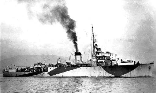
HMS Vestal
Written by Stephen Burton
(Phuket, Southern Thailand)
Depth 70meters ; Trimix diving only
“The last British Royal Naval vessel sunk during WWII”
Details of Sinking:-
The HMS Vestal, an Algerine class minesweeper was hit by a Japanese kamikaze plane during the closing days of WWII, the Vestal was extensively damaged and was deemed unrepairable. Due to it’s closeness to Japanese held territory (Thailand), the crew were taken off, and the vessel was destroyed & scuttled to prevent it falling from into enemy hands.
Discovery of the wreck:-
As with many shipwrecks lost far out at sea during WWII, the precise location of the HMS Vestal either through reasons of disinformation or navigational uncertainty was unknown. The best positional accuracy that can be hoped from historic records of this time be a square mile box and thus it was up to modern tech divers to ‘liaise’ with local fishermen (for ‘liaise’ read ‘get them copiously drunk and release them of their GPS net snag notebook’) so as to get a good spread of net snag marks in the rough location where the HMS Vestal was known to be.
notes:- All local fishermen carrying out trawling operations keep hundreds of records of underwater ‘net snag marks’ . The majority of the marks are simply underwater rocky outcrops, However, occasionally when the net is pulled free from the snag point, bits of shipwreck come up with the net revealing the nature of the underwater obstruction.
Thus it was with the HMS Vestal, when many years a go a local Thai fisherman reported to a couple of French guys living in rented bungalows opposite the Kata post office that his net kept bringing up shipwreck debris at two separate locations that later proved to be the HMS vestal and the SS Petalin.
The HMS Petalin is recorded as being dived on air since as early as 2001 by Laurent Lefebvre and Ben Reymenants, however it was up to commercial diver Fred Evans and technical diver friends Joerg & Andreas from Deep Blue Diving in Phuket to formally investigate the net snag mark later identified as the HMS Vestal, using Trimix diving techniques during 2004
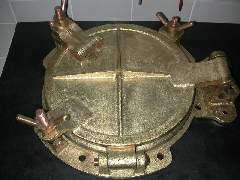
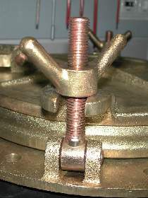
Restored HMS Vestal artifacts from the debris field such as shell cases and portholes confirmed the wrecks British origin
For more pictures of the HMS Vestal shipwreck follow this link Deep Blue Divers, Phuket
Other British Navy Warships nearby
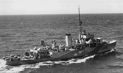
The Vestal’s sister ship the HMS Squirrel also sank nearby in around 95meters of water, together with 2 British Minisubs involved on a clandestine attack on Phuket Harbor, rumored to be resting in the silty mud somewhere.
The British Admiralty’s database reveals the following info for Minesweepers including requisitioned sunk in the Phuket Area:-
HMS VESTAL (940ton, 10/9/43) Sunk by aircraft, off Phuket, Siam (Thailand) 26 July 1945
HMS SQUIRREL (940ton, 16/8/44 Damaged by mine off Phuket, Siam (Thailand). Sunk by own forces, 24 Jul 1945
For information on other vessels in the Algerine Class Minesweepers follow these links
http://www.cronab.demon.co.uk/algerine.htm
http://www.memorials.inportsmouth.co.uk/old-portsmouth/algerine.htm
for more information on British Forces shipping Losses follow this link
http://www.naval-history.net/WW2BritishLosses1Major.htm
Wrecks details
The wreck lies upright on the bottom in 72 meters of water on a sandy seabed. As is common for this area, much of the wreck is covered in fishing nets and rope, making entanglement a problem especially for technical divers wearing 4 tanks. Divers report finding explosive ordinance present on the wreck, so don’t touch anything.
More info updated Feb 2018 by Peter Goebels
We added a Mooring line at the GPS coordinates. N 07 41.531 E 098 15.573
There were two large fishing vessels dragging a net which made visibility almost zero.
Next trip we will take DPV’s and shoot videos and stills.
More underwater images of the HMS vestal are given here
http://www.histarmar.com.ar/HYAMNEWS/HojaInformativa/HojaInf41.htm
GPS Location:-
Near Phuket WGS84 N07′ 41.530″ E098′ 15.560″
Last dived by:- Fred Evans and Friends Joerg & Andreas who run Deep Blue Divers, Phuket